Return to All Folder Listing
| Filename | ISS View Loop South America 1.CC-BY.NASA.mp4 |
|---|---|
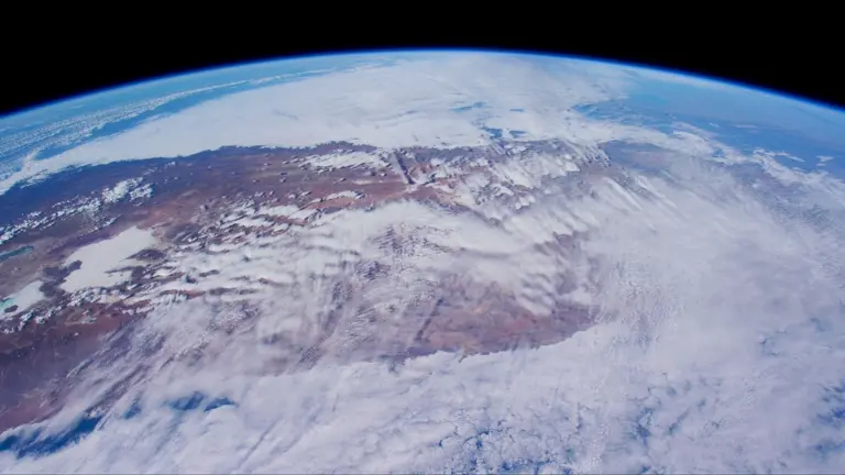
| Desc | The view looks towards the southeast as the International Space Station crosses South America. The coast of Chile is visible in the lower right, with the Andes rising sharply upwards under a partial cloud cover. On the left, in southwestern Bolivia, is the Salar de Uyuni, the world’s largest salt flat, visible as a bright white area. As the International Space Station orbits to the southeast, you can see the desert region of the Andes in northern Argentina give way to more fertile areas. The Salinas Grandes and other salt flats come into view in the right side of the image, framing Mar Chiquita Lake or "The Little Sea." The valley of the Paraná River curves southward towards Rosario and Buenos Aires, its dark verdure giving the appearance of an immense lake. Clouds cover the eastern coast of Uruguay and Argentina, with a contrail stretching to the west from Buenos Aires. Weather patterns along the prevailing winds stretch to the horizon across the Atlantic--a view spanning a continent in just over four minutes. Edited from 4K Earth Views video from NASA: https://images.nasa.gov/details/jsc2021m000138_4K_Earth_Views_Extended_Cut_for_Earth_Day_%202021_210422-4KMP4 |
| Type | Video |
| Resolution | 1920 x 1080 |
| License | CC-BY |
| Attribution | NASA |
| Collection | videos |
| Folder | Motion Backgrounds |
|
Download Medium Download Large Image Source Browse Folder (Medium Resolution) Browse Folder (High Resolution Show in Interactive Search | |
| The Virtual Bible Snapshot Project provides free artwork to illustrate the Bible and Bible topics, including video, photographs, illustrations, and AI Generated artwork. Creative-Commons licensed and public domain sermon graphics for pastors, teachers and more! Learn more at snapshots.vrbm.org. | |